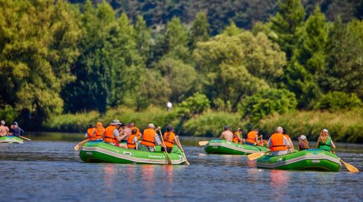
"Błękitny San" is the main water trail in Podkarpackie
SZLAK WODNY
"BŁĘKITNY SAN"
Trasa szlaku:
Zwierzyń – Lesko – Zagórz – Sanok – Hłomcza – Ulucz – Dynów – Dubiecko – Krzywcza – Krasiczyn – Przemyśl – Radymno – Jarosław – Rzuchów – Rudnik – Ulanów – Czekaj Pniowski
Długość trasy: ok. 330 km
River is 457.8 kilometres long, and its basin comprises an area of 16,900 km2. At the distance from its spring area to Przemyśl, at the edge of the Carpathians, the river meanders through the mountainous terrain, at times creating picturesque ravines, carving deep into flysch rock formations. The 158 kilometre long part of the river from Zwierzyń to Przemyśl is excellent for kayaking, and the best time for boating tours is in April, May and June. Along the river there are numerous leisure centres and accommodation facilities so you do not need a tent. To make use of the energy of the fast running river, in the mid-20th century large hydropower plants were built along the San, in Solina and Myczkowce. Poland’s largest artificial lake was created following construction of the dam in Solina. With a surface of 2.2 thousand hectares, this is an absolutely wonderful place for enthusiasts of water sports.
From Przemyśl to the area where it joins with the Vistula, the San river flows winding gently through low lands and along the route of 173 kilometres it is accessible for various shallow flat-bottom boats. The river bed is partly regulated, yet its high-rising banks are frequently inaccessible. In other areas you can encounter stony or sandy beaches, the latter are excellent for sunbathing. The overflow areas in the river valley comprise meadows and riparian forests, and the numerous oxbow lakes reveal the former meanderings of the river. The San flows into the Vistula river, at 279.7 km of its course, near Dąbrówka Pniowska, not far from Sandomierz. Characteristic parts of the water trail:
- border-area part of the upper San, from the mouth of the Negrylów stream to Procisne;
- part required for PTTK Mountain Kayaking Badge, from Procisne to Rajskie;
- waterway of the central San, from Zwierzyń to Przemyśl;
- waterway of lower San, from Przemyśl to the outflow into the Vistula.
The Route: Zwierzyń – Lesko – Zagórz – Sanok – Hłomcza – Ulucz – Dynów – Dubiecko – Krzywcza – Krasiczyn – Przemyśl – Radymno – Jarosław – Rzuchów – Rudnik – Ulanów – Czekaj Pniowski
Length of the Route: approx. 330 km
Photo: Michał Bosek
Sprawdź podobne