We start the journey from Wetlina - Stare Sioło
ROUTE
Wetlina - Orłowicza Pass - Połonina Wetlińska (Osadzki Wierch) - Hasiakowa Skała - Wyżna Pass
DISTANCE
12 km
DIFFERENCE IN ALTITUDE
+750m/-500m
ESTIMATED TIME
4h
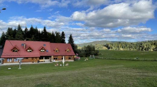
We follow the yellow tourist trail. Initially, the route goes along an asphalt road, and then a wide dirt road. We reach the forest border and the checkout point of the Bieszczady National Park (BdNP). After about 2 kilometres we pass a tourist shed. In front of us there is a perch where we should be very cautious. The railing helps in this. We reach the Orłowicz Pass. We join the Main Beskids Trail marked in red. We’re going east. We follow the ridge through Szare Berdo, and we pass the bent forms of dwarf beech. In front of us there is the ridge of Hnatowe Berdo, and then the highest point on the route - Osadzki Wierch. Behind the peak we pass a shepherd’s hut with periodic grazing of sheep. We come to Hasiakowa Skała - a new hostel was built here on the site of the legendary Chatka Puchatka. From here we go south (yellow trail) to the Wyżna Pass, where there are two monuments: one dedicated to Jerzy Harasymowicz, and the other dedicated to the victims of the mountains and to rescuers.
GOOD TO KNOW
In the chronicles of the Bieszczady GOPR group (the Mountain Volunteer Rescue Service), during the half-century of the unit’s existence 99 deaths were recorded.
The Main Beskids Trail is the longest tourist trail in Poland and is 500 km long.
There is a legend related to Hnatowe Berdo, about a knight and his loved one, who was killed by Hungarian mountain hooligans. Desperate Hnat wandered on his horse on Wetlina ridge. He fell into the abyss and died.
Photo: Joanna Siast
Sprawdź podobne