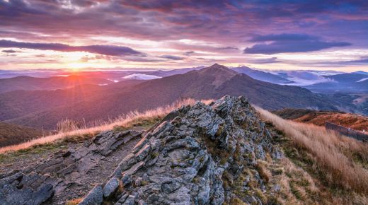
We start the route at the checkout point of the Bieszczady National Park
ROUTE
Wołosate - Przełęcz Bukowska - Rozsypaniec - Halicz - Przełęcz Goprowska - Przełęcz Siodło (Krygowskiego) - Tarnica (1346 m n.p.m.) - Przełęcz Siodło - Wołosate
DISTANCE
21 km
DIFFERENCE IN ALTITUDE
+870m/-870m
ESTIMATED TIME
6h 30min
Download folder MOUNTAINS WITHOUT BORDERS
We follow the red tourist trail east, along an asphalt-gravel road to the Bukowska Pass, where there is an ecological toilet and a tourist shed. We go to Rozsypaniec, which has rock forms. We reach the peak of Halicz. We go down the slopes of Krzemień to the Goprowska Pass. We reach the Siodło Pass by walking along a steep path. On our way there are anti-erosion thresholds, commonly known as stairs. From here, we follow the yellow trail to the top of Tarnica. After 15 minutes we reach a metal cross at the top of the hill. We return to the Krygowski Pass. We follow the blue tourist trail and go along the so-called stairs down. On the way we pass a tourist shelter. We end the expedition at the starting point.
GOOD TO KNOW
Wołosate is the southernmost town in Poland.
Wyhorlat (Slovakia), visible from Tarnica, consists of volcanic rocks.
Several dozen metres east of the trail, on the Bukowska Pass, is the border with Ukraine. Episodes of the popular series Wataha were shot here.
On the Goprowska Pass, until 2010, there was a seasonal GOPR post in the form of a tent.
Photo: Marcin Puc
Sprawdź podobne